Cool Justice in Hot Cities: Pocket Green Spaces Within Reach
Today we focus on equitable access to pocket green spaces in heat-stressed urban districts, showing how small, shade-rich refuges located close to home can lower heat exposure, uplift public health, and build neighborhood pride. We connect design decisions, funding strategies, and community voices to ensure every resident, regardless of income, age, or ability, can find restorative shade and breathable air within a comfortable, safe, and dignified walk from their front door.

Why Small Parks Make a Big Difference
Though tiny on a map, these green refuges dramatically soften harsh street temperatures, interrupt long stretches of asphalt, and invite neighbors to pause, breathe, and connect. When created where heat concentrates and access is scarce, they deliver outsized benefits, from lower surface temperatures and improved air quality to mental refreshment and social ties. Equitable distribution ensures the people facing the hottest sidewalks and longest workdays can actually reach cooling relief easily, safely, and regularly.


Mapping Fairness: Data-Led Approaches
Overlay land surface temperature, nighttime heat retention, asthma emergency visits, pedestrian injury rates, and public restroom access with school routes and senior housing. These layers expose compounding burdens concentrated on a few blocks. By adding distance-to-shade metrics and crosswalk availability, placement becomes practical, not theoretical. The result is a shortlist of locations where a small cooling refuge can reduce health risks, improve comfort during errands, and anchor safer, greener daily routines year-round.
Residents know precisely which corners scorch at 3 p.m., which fences reflect punishing glare, and where water fountains actually work. Walk the map with them, capture infrared photos, and log midday bench temperatures. Invite stroller users and wheelchair riders to test access routes and grade steep curbs. These collaborative audits transform abstract indicators into vivid priorities, ensuring budget and attention land on the spots where comfort, safety, and dignity immediately and measurably improve for local people.
Translate equity goals into measures that change daily life: every resident should reach at least one shaded seating area within five minutes, experience noticeably cooler surfaces along the way, and have water and rest without barriers. Track canopy gain, shade coverage at peak sun, and evening heat retention reductions. Publish these metrics clearly, revisit them with community review, and adjust designs. Accountability builds trust, accelerates learning, and steadily expands the web of reachable, restorative coolness.
Designing Pockets That Actually Cool
Beauty matters, but comfort during extreme heat is nonnegotiable. Prioritize deep shade from layered trees and structures, light-colored pavements that reflect rather than store heat, and plantings that thrive without constant irrigation. Add drinking water, tactile wayfinding, and seats with backs and arms. Consider misters where humidity allows, and provide wind channels for evening comfort. When every detail centers thermal relief and inclusive use, small footprints become mighty engines of health, delight, and resilience.
Overcoming Barriers to Genuine Access
Finding Space in Tight Grids
Look for slivers hiding in plain sight: bulb-outs at crosswalks, dead-end alleys, triangle islands, oversized medians, and vacant storefront setbacks. Partner with schools for shared access after class, and explore rooftops or parking-lot corners with structural assessments. Modular planters, foldable shade, and movable seats make micro-sites flexible and fast to deliver. Each reclaimed meter stitches another cooling bead onto a walkable necklace of shade, incrementally transforming overheated blocks into a humane, breathable daily landscape.

Shared Care, Shared Confidence
Trust grows when neighbors help run the place. Microgrants for local gardeners, vendor permits tied to upkeep, and youth crews trained in pruning and irrigation keep spaces tidy and loved. Clear maintenance schedules, transparent budgets, and responsive channels for reporting issues prevent decline. When caretaking honors community knowledge rather than outsourcing everything, pride rises, vandalism drops, and the pocket becomes a reliable stop for cool air, friendly faces, and small celebrations that knit streets together.

Comfort for Every Body
True access includes shade along routes, slip-resistant surfaces, tactile indicators, and benches with diverse heights. Provide stroller-friendly paths, turning radii for mobility devices, and quiet corners away from noise. Sensitive lighting supports safety without harsh glare. Multilingual, pictogram-rich signage welcomes newcomers. Consider prayer needs, food traditions, and cultural gathering patterns when placing water, picnic areas, and seating clusters. Design that respects differences turns simple greenery into a cherished, confidence-building refuge for everyone, every day.
Funding and Policy That Make Shade Inevitable
Braiding Dollars for Durable Care
A resilient pocket needs more than installation cash. Combine municipal capital, hospital community-benefit dollars, philanthropy, and utility rebates to fund both build-out and long-term care. Lock maintenance into multi-year agreements, and align with workforce programs that train local residents in arboriculture, irrigation, and safety checks. This braided model keeps fountains flowing, trees thriving, and benches welcoming, ensuring cooling relief does not vanish when the first grant sunsets or leadership changes.

Smart Rules, Fast Delivery
Streamlined permits, flexible right-of-way use, and zoning that rewards shade can shrink delivery timelines from years to months. Adopt inclusionary greening for new projects, reduce parking minimums to free land, and allow interim, tactical installations while permanent work advances. Standard details for shade structures, soil cells, and curb ramps prevent redesign churn. By treating heat relief like essential infrastructure, cities unlock quick, replicable steps that multiply comfortable corners across the hottest, most underserved blocks.
Maintenance Is Equity
If the drinking fountain is broken or the lights fail, access collapses. Budget operations from day one, assign clear responsibility, and publish service standards residents can track. Train local crews and pay living wages to stabilize expertise. Monitor tree health, irrigation leaks, and surface temperatures seasonally. Consistent care is not glamorous, yet it converts good intentions into daily comfort and trust, proving that cool, dignified spaces will endure as summers intensify and needs grow.

Stories From Hot Blocks
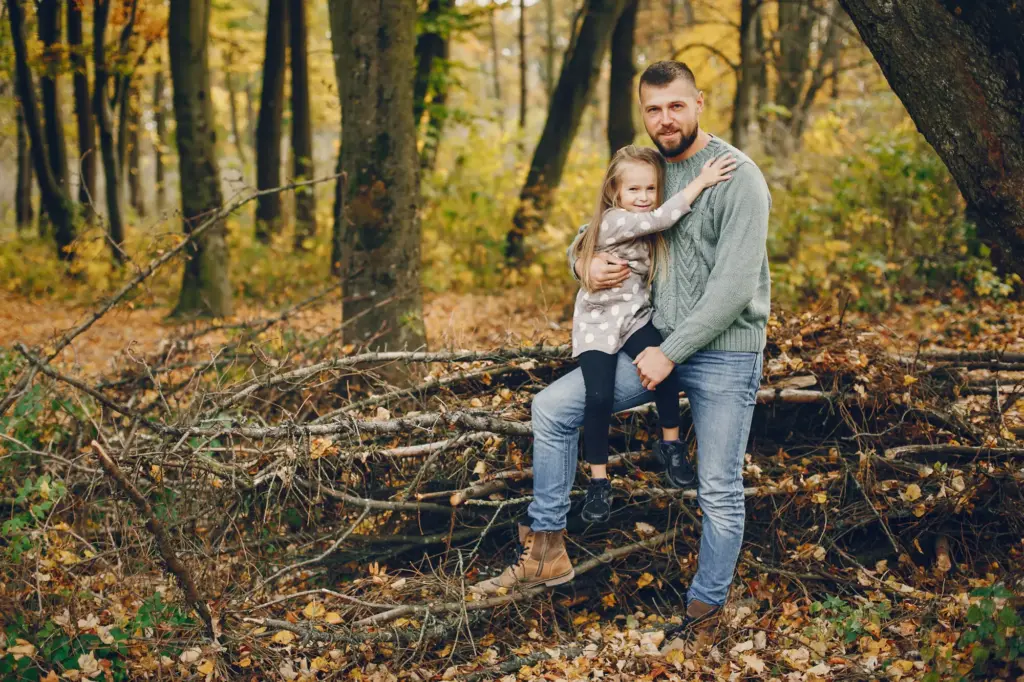
Real lives change when comfort becomes reachable. A cluster of trees beside a bus stop turns a punishing wait into a calm pause. A former asphalt corner behind a clinic now hosts chess under vines while children sip water. A shaded path stitches two schools, letting caregivers linger and talk. These glimpses reveal how tiny, well-placed pockets soften long days, spark friendships, and keep elders active, transforming heat-season dread into everyday, neighborly relief.
Get Involved and Measure What Matters
Equitable cooling grows with your participation. Organize a shade walk with neighbors, log the hottest corners, and share photos, stories, or infrared snapshots. Nominate overlooked sites, advocate for five-minute access goals, and volunteer for stewardship. Subscribe for practical toolkits, seasonal care reminders, and policy updates you can bring to local meetings. Your lived experience sharpens priorities, sustains funding, and keeps the focus on daily comfort, so every block gains a reachable patch of breathable calm.
Host a Neighborhood Shade Walk
Pick the hottest hour, trace common routes to transit, clinics, groceries, and schools, then document obstacles: glare, broken shade, missing benches, or inaccessible curbs. Invite elders, caregivers, and wheelchair users to lead. Upload your findings to an open map and present them to local staff. These walks turn abstract heat charts into urgent, human stories that guide investments toward spots where a single bench, tree, or trellis can unlock reliable comfort quickly.
Adopt a Pocket, Grow Belonging
Form a small crew to sweep, water, and check fixtures weekly, and coordinate with city teams for repairs beyond your scope. Celebrate milestones with seasonal planting days and storytelling circles. Track peak-sun shade coverage, hydration station uptime, and visitor sentiment. Share results publicly so others learn and pitch in. Caretaking creates friendships, deters neglect, and ensures the space delivers dependable relief, especially during the most dangerous weeks when consistency and trust matter most.
Share Your Data and Your Voice
Comment with your experiences of the hottest blocks, upload before-and-after photos, and tell us how a nearby pocket changed errands, commutes, or caregiving. If you collect simple surface readings or shade timing, post them so neighbors and officials learn together. Subscribe for guides, funding alerts, and design templates you can adapt locally. Your insights and advocacy keep momentum grounded in real needs, ensuring cooling benefits reach those who most urgently need them.
All Rights Reserved.